
Land and peoples
Gombe State lies in the centre of north-eastern Nigeria and covers about 20,265 square kilometres. It borders Borno, Yobe, Adamawa, Taraba and Bauchi states. The south-east is hilly and mountainous, while the centre, north and west are mostly open plains of savannah grassland.
The state is home to many peoples, among them the Fulani, Tangale, Waja, Bolewa, Tera, Jukun, Jara, Pero, Tula, Cham, Longuda, Dadiya, Kamo, Awak and Kanuri, as well as Hausa, Yoruba and Igbo communities. Commonly spoken languages include Fulfulde, Tangale, Tera, Waja and Kanuri, with Hausa serving as the main language of trade.
The founding of the emirate
The modern state traces its story to the early nineteenth century and the jihad led by Uthman dan Fodio, which created the Sokoto Caliphate. Buba Yero (Abubakar), a follower of dan Fodio, founded the Emirate of Gombe in 1804. A study by historian Jörg Adelberger records that Buba Yero was recommended to dan Fodio by Yakubu of Bauchi, and that even before the jihad he had begun conquering groups near the Muri Mountains. His campaigns reached the Jukun towns of Pindiga and Kalam and the Tangale, Waja, Tera, Biu, Kanakuru, Yungur, Longuda, Bachama, Lala and Mbula, and he crossed the Benue River into Adamawa. The Gombe State government gives the date of the jihad period as about 1800, so the exact year of founding varies between sources.
The capital and the early emirs
The emirate’s headquarters was set up at Gambe around 1824. In 1841 it was renamed Gombe Aba, meaning “Old Gombe”, and it remained the seat of government for the emirate.
Buba Yero’s son, Muhammadu Kwairanga, ruled from 1844 to 1882 and subdued the Tangale, Waja, Dadiya and Cham. Gombe often granted conquered areas to leading officials as fiefs: the Plains Waja and Western Tangale were given to the Sarkin Yaki and the Galadima of Gombe, and the people paid tribute in return for protection from raids. Over time the emirate’s control over these chiefs weakened. In about 1886, the emirs of Gombe and Misau attacked the Tangale of Shongom and were driven back, and the Emir of Misau was killed. The emirate prospered until the 1880s, when religious conflict and the approach of the British disrupted it.
A religious challenge and the British
Zailani ruled from 1882 to 1888. In his reign, a religious leader called Malam Jibrilla set up at Burmi and refused to accept the emir’s authority. Gombe could not subdue him, and he was only defeated by the British Bauchi-Borno expedition in 1902. He was later exiled to Lokoja.
With the British came a new order. The emirate’s power ended, and the territory was administered through two units, the Gombe Native Authority and the Tangale-Waja Native Authorities, which together formed Gombe Division. The division’s headquarters moved to Nafada in 1913, and then to what is now Gombe town, which was renamed from Doma. Sources give the year of the second move as 1918 or 1919.
From independence to statehood
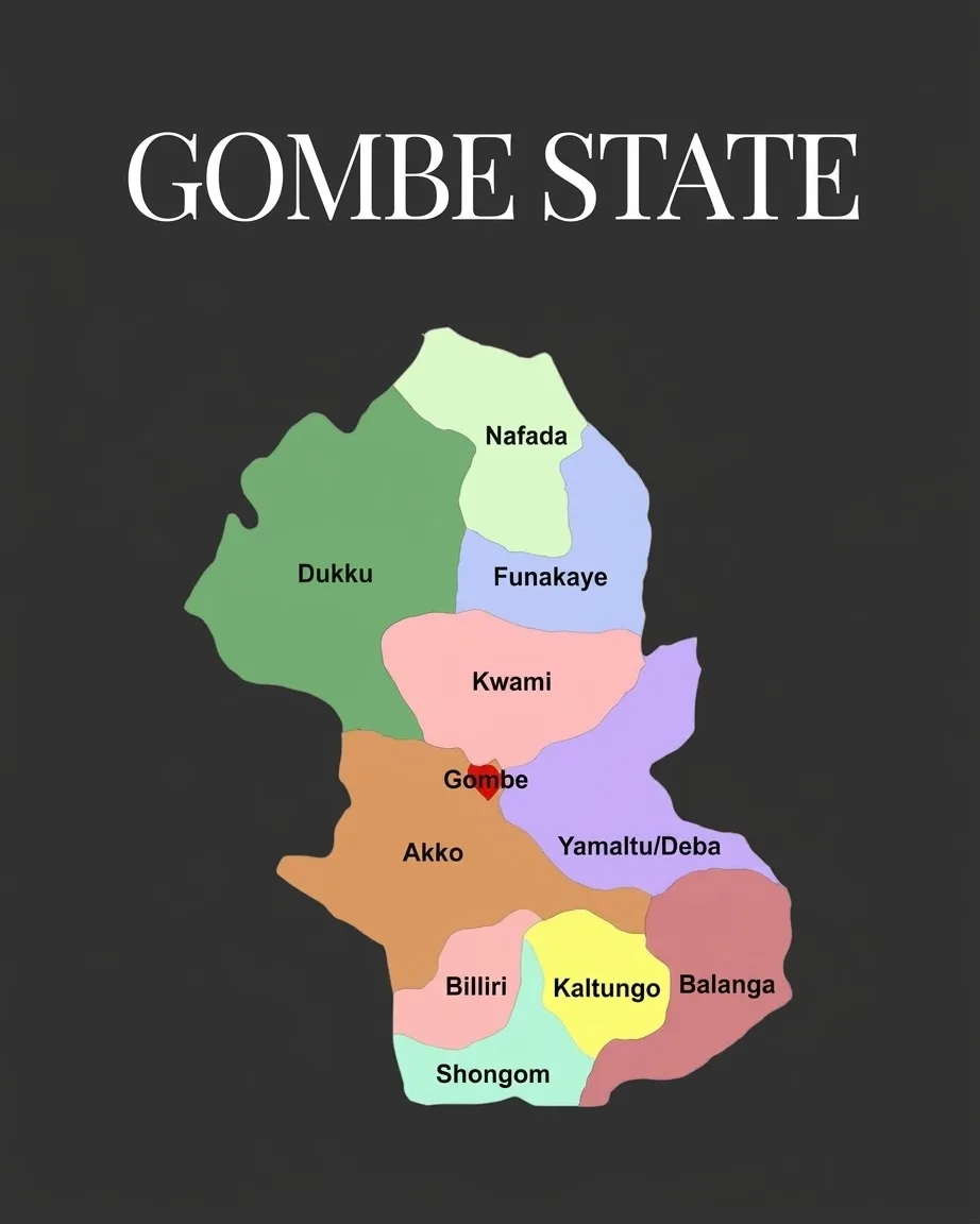
After independence in 1960, military administration brought changes that produced local government authorities, and from 1976 the two native authorities evolved into today’s eleven local government areas: Akko, Balanga, Billiri, Dukku, Funakaye, Gombe, Kaltungo, Kwami, Nafada, Shongom and Yamaltu-Deba.
On 1 October 1996, Gombe was carved out of Bauchi State by the government of General Sani Abacha, fulfilling a long-held local wish for a state of its own.
Economy and place today
Gombe town lies in the wooded savannah of the Gongola River basin and is a major collection point for groundnuts and cotton, especially since the railway opened in 1963. It is also a trading centre for sorghum, millet, cowpeas, beans and onions, and a place where cotton weaving and dyeing are traditional crafts. Limestone nearby led to a cement factory at Ashaka in the early 1970s, and the Dadin Kowa Dam is on the Gongola River. Britannica estimated the urban population at about 460,000 in 2016.